
Communication
Explaining the plan, sharing the work. Maps that help people see what's coming, where, and what it means for them.
Stakeholder interaction
Hearing what matters, keeping in touch. Maps that gather responses by location and track conversations over time.
Project management
Tracking the work, accounting for results. Maps that show progress and report it to the people who need to know.
A task, a map
Three fields of work, each with its own maps
COMMUNICATION
Explain a plan, share the work.
Maps that help people see what's coming, where, and what it means for them.
STAKEHOLDER INTERACTION
Gather input, stay in touch.
Maps that collect responses by location and track conversations over time.
PROJECT MANAGEMENT
Track the work, report results.
Maps that show progress and report it to the people who need to know.
A task, a map
Three fields of work, each with its own maps
Connecter les projets à
leur territoire et aux citoyens
A task, a map
Plan Map
Montrer l'impact spatial d'un plan sur son environnement.
Communication


Participation Map
Recueillir les retours des parties prenantes de manière structurée sur la carte.
Stakeholder interaction

Detour Map
Communiquer les itinéraires de déviation pendant les travaux.
Communication
Can’t find the exact map you need? We create custom maps, fully tailored to your specific task and project.

Connecter les projets à
leur territoire et aux citoyens
The power of maps
Maps anchor information to location. Instead of plans in documents, updates in emails and feedback in spreadsheets, everything comes together in one place, pinned to exactly where it matters.
Zoom in to what's relevant to you. Zoom out to see the full picture. Compare situations over time.
The right map makes spatial information accessible to everyone involved — not just those who know where to look.
Connecter les projets à
leur territoire et aux citoyens
The right map for every situation

Information Events & Presentations
Make complex plans tangible for a large audience. Project your maps onto big screens or let stakeholders navigate the details themselves on interactive touchscreens. Instead of static, unreadable PDFs on a bulletin board, bring your project to life dynamically during public hearings or office sessions.

One-on-One Meetings & Work Sessions
Need to engage in-depth with direct neighbors, landowners, or project partners? Take your laptop or tablet straight to the kitchen table or the construction site office. Zoom in together to discuss specific plots, design variants, or the exact local impact. This builds maximum transparency and mutual trust.

Online & Standalone Use
Give everyone the freedom to explore the plans in their own time. The maps are fully web-based and optimized for PC, tablet, and smartphone. Visitors can easily scroll through all information right from their couch and leave feedback or questions online whenever it suits them best.

MAP IN THE SPOTLIGHT
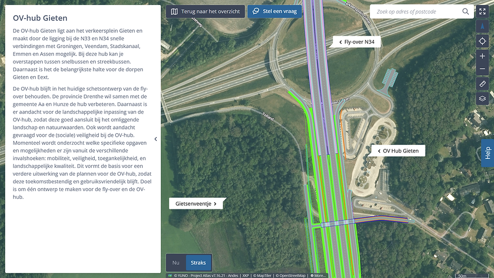
Participation map
Residents and stakeholders want to think along, but their input arrives through email, public meetings, online forms and social media. Scattered, disconnected from locations, hard to revisit.
The participation map gathers responses by location, visible to everyone. What was said, where exactly, and when. The project team sees patterns. The resident sees their input was heard.
" The Project Atlas was a highlight at our information day in Elstorf. Many visitors took the opportunity to view the plans on the interactive map. The project keeps attracting visitors daily."
Dirk Möller
Head of the Lüneburg branch, Lower Saxony State Authority for Road Construction and Traffic (NLStBV)