
Communicatie
Het plan uitleggen, het werk delen. Kaarten die mensen helpen zien wat er komt, waar, en wat dat voor hen betekent.
Bekijk de kaarten →
Stakeholder interactie
Horen wat er speelt, contact onderhouden. Kaarten die reacties verzamelen per locatie en gesprekken bijhouden over tijd.
Projectmanagement
Het werk bijhouden, resultaten verantwoorden. Kaarten die voortgang tonen en rapporteren aan de mensen die het moeten weten.
Bekijk de kaarten →
Een taak, een kaart
Drie werkvelden, elk met eigen kaarten
COMMUNICATION
Licht een plan toe, deel het werk.
Kaarten die mensen laten zien wat er aankomt, waar, en wat dat voor hen betekent.
STAKEHOLDER INTERACTION
Haal input op, blijf in contact.
Kaarten die reacties per locatie verzamelen en gesprekken over tijd bijhouden.
PROJECT MANAGEMENT
Volg het werk, rapporteer de resultaten.
Kaarten die voortgang tonen en daarover rapporteren aan wie het moet weten.
Een taak, een kaart
Drie werkvelden, elk met eigen kaarten
Uitgelichte kaarten
Een taak, een kaart.
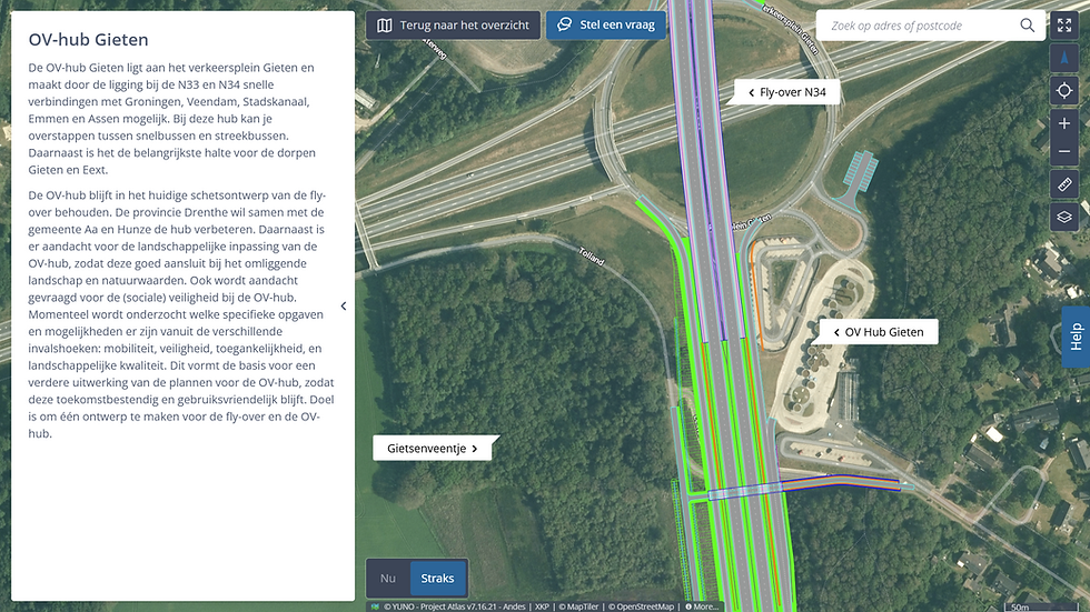
Plankaart
Ruimtelijke impact van een plan op de omgeving laten zien.
Communication


Participatiekaart
Stakeholderfeedback gestructureerd verzamelen op de kaart.
Stakeholder interaction

Omleidingskaart
Omleidingsroutes communiceren tijdens werkzaamheden.
Communication
Niet de exacte kaart gevonden die je zoekt? Wij maken kaarten op maat, volledig afgestemd op jouw specifieke taak en project.

filosofie
De kracht van kaarten
Kaarten koppelen informatie direct aan een locatie. In plaats van plannen die verstopt zitten in documenten, updates in e-mails en feedback in spreadsheets, komt alles samen op één centrale plek: gepind op de locatie waar het er daadwerkelijk toe doet.
Zoom in op wat voor u relevant is, of zoom uit om het grotere plaatje te zien. Vergelijk situaties moeiteloos door de tijd heen.
De juiste kaart maakt ruimtelijke informatie toegankelijk voor iedereen — niet alleen voor de experts die weten waar ze moeten zoeken.
IN DE PRAKTIJK
De juiste kaart voor elke situatie

Informatieavonden & Presentaties
Maak complexe plannen tastbaar voor een grote groep. Projecteer de kaarten op een groot scherm of laat stakeholders zelf navigeren op interactieve touchscreens. In plaats van statische, onleesbare PDF’s op een bord, breng je het project live en dynamisch in beeld tijdens bewonersavonden of kantoorsessies.

1-op-1 Gesprekken & Werksessies
Diepgaand in gesprek met direct omwonenden, grondeigenaren of projectpartners? Neem de laptop of tablet mee naar de keukentafel of de bouwkeet. Zoom samen in om direct specifieke kavels, varianten of de exacte lokale impact te bespreken. Dit zorgt voor maximale transparantie en wederzijds vertrouwen.

Online & Standalone Thuisgebruik
Geef iedereen de ruimte om de plannen in hun eigen tijd te bekijken. De kaarten zijn volledig webbased en geoptimaliseerd voor pc, tablet en smartphone. Bezoekers kunnen thuis vanaf de bank rustig door alle informatie scrollen en direct online hun feedback of vragen achterlaten wanneer het hen uitkomt.

KAART IN DE SCHIJNWERPER
Participatiekaart
Bewoners en stakeholders willen meedenken, maar hun input komt binnen via e-mail, inloopavonden, online formulieren en sociale media. Verspreid, losgekoppeld van locaties, lastig terug te vinden. De participatiekaart verzamelt reacties per locatie, zichtbaar voor iedereen. Wat er is gezegd, precies waar, en wanneer. Het projectteam ziet patronen. De bewoner ziet dat zijn inbreng is gehoord.
Lees meer over de participatiekaart →
"De Project Atlas was in februari 2024 een trekpleister op onze informatiedag in Elstorf. Veel bezoekers maakten van de gelegenheid gebruik om de plannen op de interactieve kaart te bekijken. De kaart trekt nog dagelijks veel online bezoekers."
Dirk Möller
Hoofd vestiging Lüneburg, Niedersächsische Landesbehörde für Straßenbau und Verkehr (NLStBV)
Onze opdrachtgevers


